When it comes to accurate mapping, planning, and analysis, traditional aerial photographs often fall short due to distortions caused by camera tilt and terrain variations. You need a truly precise, measurable view of your project site.
For Business Enquiry
At AVbimsoft, we specialize in delivering high-resolution Orthophoto Services that provide an uncompromised, geometrically corrected representation of your reality. We transform raw aerial imagery (from drones, aircraft, or existing datasets) into a single, seamless, and incredibly accurate orthomosaic map, ready for direct measurement and integration with your GIS and CAD systems.
An orthophoto is a georeferenced aerial image that has been geometrically corrected ("orthorectified") to remove the effects of terrain relief and camera tilt. This process ensures that the scale is uniform throughout the image, making it as accurate as a map. Unlike a standard aerial photograph, you can take precise measurements, distances, and areas directly from an orthophoto.
Global Clients
Ongoing project
Reduction in Project Costs
Global Clients
Faster Project Delivery
Countried served
Our Comprehensive Services Portfolio

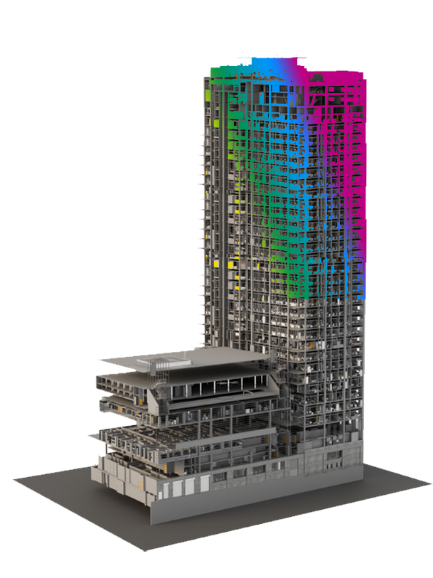
Step into the future of construction documentation with AVBIMsoft's Scan to BIM and CAD services.

Step into the future of construction with our cutting-edge AR and VR services. Experience immersive virtual project tours, real-time design visualizations, and effortless collaboration.

Expert BIM Service Providers for accurate quantity takeoffs and cost estimates

Explore AVBIMsoft’s Comprehensive photogrammetry services included in Geospatial service with real-time Plannings

Get precise mapping, detailed terrain analysis, and the creation of accurate orthophotos.

Streamline the solutions that deliver valuable insights and enhance the success of your projects

Explore AVBIMsoft’s comprehensive Geospatial Services, including photogrammetry, Lidar qualification, and orthophoto generation.

Enter the world of creativity with AVBIMsoft’s Visualization Services.

Enhance your architectural and construction projects with AVBIM premier CAD to BIM Modeling and BIM Services

Transform your architectural and construction projects with AVBIM advanced Scan to BIM Services
By partnering with us, you gain:
Our orthophotos are meticulously corrected to ensure pixel-perfect alignment and true-to-scale representation, essential for reliable measurements and analysis.
Experience a uniform scale across the entire map, free from the perspective distortions of raw aerial photos.
Capture intricate features and critical details of your site, providing clarity for even the most complex projects.
Our methods allow for rapid capture and processing, significantly reducing project timelines compared to traditional surveying.
Perform accurate distance, area, and volumetric calculations directly within the orthophoto, saving time and reducing fieldwork.
Our deliverables are provided in industry-standard formats, ensuring effortless integration into your existing GIS, CAD, and BIM workflows.
Why Choose AVBIMsoft Services?
Driven by a commitment to accuracy, efficiency, and innovation, AVBIMsoft takes a holistic approach to converting the physical world into a digital environment. Our use of advanced technologies ensures data precision, empowers smarter decision-making, and improves project workflows. The benefits of outsourcing AVBIMsoft services to us include:

Precise Solutions for Unmatched Project Results


Leveraging nearly two decades of expertise in business process management and a deep understanding of the AEC industry's demands, AVbimsoft delivers orthophoto solutions that are both technically superior and strategically beneficial.